 The plan’s most significant feature is infusion of new developable land for the city.
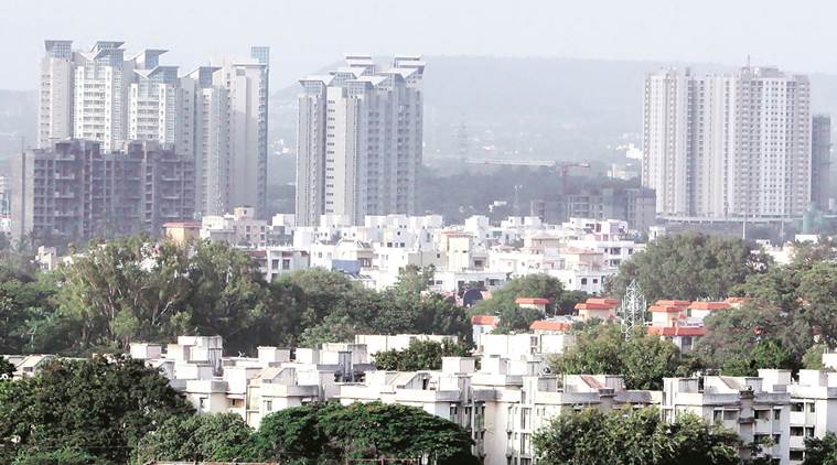
THE MAHARASHTRA government on Tuesday approved Mumbai’s long-pending Development Plan (DP), paving the way for the city to have more land available to build homes and commercial spaces. Chief Minister Devendra Fadnavis sanctioned the new 20-year development blueprint on Tuesday. An official announcement is set to follow on Wednesday. Officials said the new plan’s most significant feature is the infusion of new developable land
for the space-constrained city. It proposes to unlock about 3,734 hectares of public and privately owned lands — currently tagged as no development zones (NDZ) — to push low-cost housing and augment social amenities.
This is the largest addition to the city’s developable land bank in recent history. Statistically, the area to be added to the city’s developable land bank accounts for over eight per cent of Mumbai’s total area of 45,829 hectares.
In 2017, the World Economic Forum, citing a UN-Habitat report, had ranked Mumbai as the second most overcrowded city after Dhaka, with an average population density of 31,700 people per square kilometre. Despite this, Mumbai’s new development control (DC) regulations, which will kick in with the new DP, will further raise construction rights for various special projects in the commerce, hospitality and redevelopment sectors.
In a shift from prevalent regulations where permissible floor space index (FSI) levels in the island city were lower than those in the suburbs, Fadnavis has lifted this curb, raising FSI levels in the island city up to 3, while that in the suburbs has been retained at 2.5.
FSI, also known internationally as floor area ratio, is a tool that defines the extent of construction permissible on a plot; the ratio of total built-up area to the total plot area. Enhancing the construction area on a plot, the new rules say FSI will be calculated on the gross plot area, excluding land under reservations, and won’t involve deduction of amenity open spaces and recreational open spaces.
On Tuesday, Fadnavis also sanctioned a proposal to publish a list of modifications that the government wants to carry out in the new DP, most of which deal with increasing FSI and modification of public reservations. Sources said these would be published as the ‘excluded part’ of DP-2034. Public suggestions and objections will be invited for the excluded part.
Government and private town planners, however, agreed that the infusion of the new developable land is the most prominent feature of the DP. While Mumbai’s existing development plan had focussed on creation of ‘affordable’ housing through redevelopment, the DP-2034 has targetted construction of 10 lakh ‘affordable’ homes through the unlocking of the NDZ areas, including salt pan lands and lands earlier earmarked for tourism development.
Statistics show that about 16,693 hectares had been earmarked as NDZ in the current plan. But DP-2034 further divides this green space into two sub-categories. About 12,859 hectares has been newly tagged as “natural area” (NA) where construction will continue to be barred. The NA lands include areas under the Sanjay Gandhi National Park, mangroves, hills, ecologically vital salt pans, parts of the Film City land, Aarey Milk Colony and areas falling in the coastal regulation zone-1. That leaves 3,734 hectares classified as NDZ, which is proposed to be released.
If owners of these lands construct affordable homes and social amenities on 33 per cent of the built-up space and hand it over free of cost to the BMC, and set aside another 33 per cent area for public open spaces, the proposal is to allow them build up to three times the remaining plot area, or an FSI of 3. Those who do not avail this incentive scheme, would be permitted to utilise only the zonal floor space index of the plot in question.
Civic records show that about 74 per cent of the NDZ land to be unlocked for development is located in the Goregaon to Borivali belt in the western suburbs. Also, planning proposals on 960 hectares of such unutilised land, owned by the Mumbai Port Trust (MbPT), were withdrawn on Tuesday with the CM proposing to anoint the central agency as a ‘Special Planning Authority’ for its own land.
Incidentally, the last time there was a similar promise was in 2004, when the erstwhile mill lands in the heart of Mumbai were unlocked for similar goals, and that was only 280 hectares of newly developable land.
The government town planners and the municipality, meanwhile, is banking that the unlocking of the new land would redefine the city’s land use map. Mumbai’s latest Existing Land Use (ELU) survey had found that the 12.44 million residential population occupies barely 10327.09 hectare or 103.28 kilometer of the city’s land area. In other words, land cover under residential use is less than 22 per cent at present. The new target is to raise this to 50 per cent.
The blueprint is based on the projection that the city’s residential population will peak to 12.79 million by 2021 from 12.44 million in 2011, before dropping to 11.40 million by 2034. It has doubled the per capita housing requirement from 9 sq meter (ELU) to 18-20 sq meter. Estimating an average household size of 4.2, the new plan has projected that the city would need a residential built-up area of around 55 lakh sq m or 30 lakh homes by 2021.
The government planners claims that the release of the new land will also help augment the availability of developed public open spaces and amenity space. But while the DP-2034 has proposed increasing the open space availability per person to 4 square meter (national norm is 10-12 sq m), the DP document itself admits that the implementation of this count has been “very poor” in the past. Interestingly, a 14.96 sq km of virgin mangrove-laden land, hugging the eastern coastline from Airoli in the eastern suburbs to Sewri in central Mumbai, has been added to Mumbai’s geographical limits. It has been shown as ‘NA’ on the plan.
Another key deliverable of DP-2034 is “reasserting Mumbai’s status as the country’s commercial capital”. The existing land use shows that commercial spaces occupy just 911 hectares of the city’s total area. The target of the new plan is to enhance this to 1,272 hectares, a near 40 per cent jump. The government has undone the freeze on FSIs for commercial development in the island city, granting an FSI up to 5 for commercial developments.
“We have made spatial provisions to generate employment totalling 8 million,” Municipal Commissioner Ajoy Mehta had earlier told The Indian Express.
While the process for drawing up the new plan had begun six years ago, its verification and approval was mired in various controversies and delays. An initial draft, released in February 2015, was scrapped by Fadnavis in May that year, following a public outcry over the errors in the existing land use data and the “high” FSI levels proposed.
In May 2016, Ajoy Mehta published a revised draft plan, which had proposed a uniform permissible FSI of 2 for both the island city and suburbs. But since then the plan has witnessed several suggested revisions. In March 2017, a state-appointed planning committee, which reviewed over 12,000 public suggestions and objections to the draft plan, submitted its report recommending several changes.
On July 31, 2017, the civic general body had sanctioned the plan, along with the committee’s recommendations, and adding new suggestions of its own. Most recommendations have been rejected by the government. Many others have been included in the EP proposals.