MOST ACCURATE FORECAST: Big changes coming this week!

Cooler temps and a chance for rain is heading for the Valley for the week ahead.

PHOENIX - High cloud cover is streaming back into the state Sunday evening but not before topping out at 75 degrees.
Cloud cover will continue to thicken up on Monday with a slight chance of light showers for Phoenix and points west.
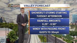
Rain chances increase as the storm system approaches Arizona on Tuesday. The best chance for rain in the Valley will come Tuesday evening and into Tuesday night as a cold front sweeps through. Rainfall totals for the greater Phoenix area look to come in between a quarter and half of an inch.
As the cold front passes through late in the day on Tuesday, expect winds to crank up out of the southwest with gusts to 30mph.
For the high country, it looks like much of the precipitation will fall in the form of rain before the cold front moves through. After the front passes, snow levels will crash to around 5,500 feet with a few inches of snow possible for northern Arizona locations by Wednesday morning.
A few isolated showers and high country snow showers will be possible through the day on Wednesday before we clear out for the rest of the week.
Valley highs will fall from the low to mid 70s on Tuesday to the low to mid 60s on Wednesday as the cold air settles in, putting us closer to normal for this time of year.
Expect highs back in the low 70s as soon as Friday as a ridge of high pressure builds in next weekend.
________________________________________
Share your weather photos and videos with us anytime. Email share@abc15.com.
_________________________________________
2018 Rainfall totals:
Sky Harbor Official Rainfall: 0.00" (-0.21" from average)
Valley Average (Phoenix Rainfall Index): 0.00" (-0.14" from average)
__________________________________________
Daily rainfall reports from all across the Valley can be found here .
__________________________________________