
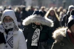


America’s winter-weary east coast is bracing for the possibility of a formidable storm dubbed a “bomb cyclone”.
Denizens of the Eastern US have already endured freezing temperatures and record snowfall in recent weeks.
Now they could be confronting another extraordinary weather event, a combination of low pressure and high winds that is riveting weather experts.
“All day Thursday meteorologists are going to be glued to the new GOES-East satellite watching a truly amazing extratopical ‘bomb’ cyclone off New England coast,” meteorologist Ryan Maue said on Twitter.
All day Thursday meteorologists are going to be glued to the new GOES-East satellite watching a truly amazing extratopical “bomb” cyclone off New England coast. It will be massive -- fill up entire Western Atlantic off U.S. East Coast. Pressure as low as Sandy & hurricane winds pic.twitter.com/6M4S3y75wT
— Ryan Maue | weather.us (@RyanMaue) January 2, 2018
While there will be coastal impacts from “bomb” cyclone -- extremely dangerous cold from brutal wind chills will wreck the Midwest and Northeast during day Friday into Saturday --> Record lows likely at most locations. @WeatherdotUS pic.twitter.com/z5vp5wC8JX
— Ryan Maue | weather.us (@RyanMaue) January 2, 2018
The confluence of extreme conditions had the National Weather Service warning people to be prepared for a powerful storm.
“In addition to snow and ice accumulations, strong winds could result in considerable blowing & drifting and possibly downed trees and/or power outages,” the National Weather Service said, adding that flooding was also a possibility.
Testifying to the storm’s potentially vast scale, the National Weather Service predicted the worst conditions would encompass an area stretching from the Carolinas to Maine — a distance of hundreds of miles.
“Bitter cold and dangerous wind chills to persist into the weekend,” the forecaster said.
Nor’easter “bomb” will be MASSIVE -- circulation will expand across 50 degrees of longitude, from Iowa into central Atlantic.
— Ryan Maue | weather.us (@RyanMaue) January 2, 2018
This 850 mb wind speed map is a classic, apex intensity "extratropical" cyclone maturing into a "warm-seclusion" or "occluded" storm ... #SoMuchJargon pic.twitter.com/6kZEUIIbvW
While regions like New England are accustomed to heavy winter weather — temperatures there could plummet to -28C — the weather service in Jacksonville, Florida was warning of rare freezing weather.
“Parts of northern Florida are likely to see a wintry mix of snow, sleet, and freezing rain from this system Wednesday morning,” meteorologist Jack Sillin wrote in a blog post.
